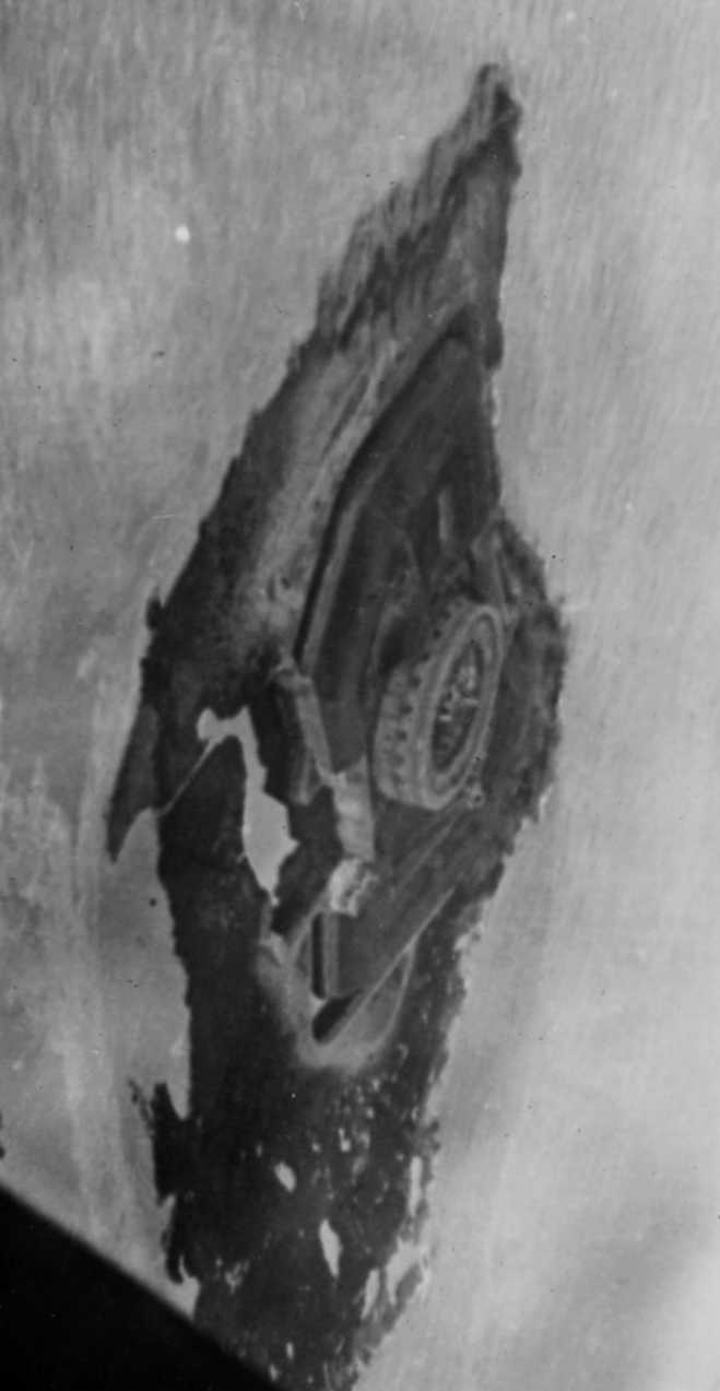
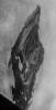
 The Barger album included this shot (at left) of an unusual circular fort situated on an
island and it kicked off a long search to identify the structure. Since the photo was shot in daylight, it certainly can't have
been taken on the D-Day run, hence it was probably during a training jump
flight. Some of these flights looped off the English coast and
then back in again to simulate an attack run.
The Barger album included this shot (at left) of an unusual circular fort situated on an
island and it kicked off a long search to identify the structure. Since the photo was shot in daylight, it certainly can't have
been taken on the D-Day run, hence it was probably during a training jump
flight. Some of these flights looped off the English coast and
then back in again to simulate an attack run.
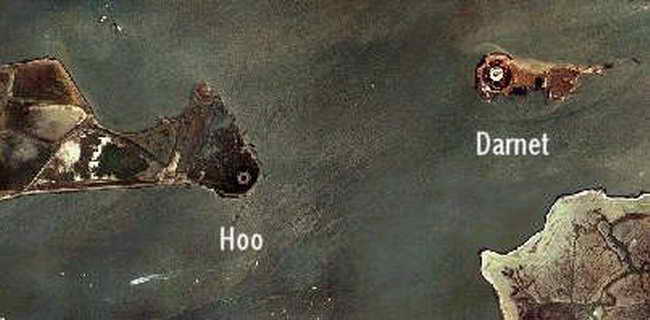
Research has
shown that there are a number of circular forts in the UK, but Forts Darnet
and Hoo which guard the entrance to the Medway River are the most likely
candidates based on their geographic proximity. These islands lie only
some 60 miles to the northeast of the Nottingham area.
Of the two, Fort Darnet affords some elements of a better match but not totally.
 Closer inspection of the satellite photo (above) gives some clues as to
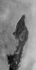 whether the
Barger aerial photo is of Fort Darnet. Many of the features are similar but
three problems thwart easy comparison. whether the
Barger aerial photo is of Fort Darnet. Many of the features are similar but
three problems thwart easy comparison.
First, the angle of the two photos differ
greatly. The satellite shot is essentially vertical while the aerial
shot was taken at an oblique angle. Secondly, the axis of each photo differs somewhat and
thirdly, the satellite photo seems to have been taken during a high tide
condition that dramatically changes the island's profile from the low tide
condition apparent in the aerial shot...
Some digital alterations were made to the
aerial shot to improve comparison of these photos.
Using the tidal pool which appears as a white spot at the 7
o'clock position on the satellite photo, we have rotated the aerial photo to
better align its axis with the satellite view. In addition, we have (somewhat crudely) estimated the high tide lines and
painted over the mud flats. The end result, especially considering
that the effects of wind and waves over the past 60 odd years have added
their touch to the shore line sculpture, suggests
strongly that this is in fact Fort Darnet.
Who's Hoo and Darnet?
Fort Darnet and Fort Hoo were built on the
recommendations of the 1859 Royal Commission on two islands covering the inner
navigable channel of the Medway. Originally designed for two tiers of
guns mounted in a circle, with a boom strung between them, there were many
problems with subsidence, and after extensive cost overruns the forts were
completed in 1871 with one tier, and 11 guns, a mixture of 9" and 7" RMLs
[Rifled Muzzle Loader], and no boom. The forts were never used in anger, and
were disarmed before WW-I. In WW-II the forts were used as observation
posts, with platforms and pillboxes built on top.
Fort Darnet was built between 1861 and 1872. Fort Hoo, which has the same design as
Darnet, was built in 1871 and lies 1 km
away on another island in the Medway. Currently both forts
are in fair condition. Fort Darnet can be freely visited by boat, though the
landing is muddy. Fort Hoo is still owned by the Ministry of Defence, and
landing is not allowed.
In 1667 the Dutch raided the Medway, then protected only by Upnor Castle.
This started a program of work to protect Chatham dockyard with the addition
of Cockham Wood and Gillingham Forts which were built in 1669 and later in
1756 the Cumberland lines, defences around the dockyard, and Fort Amherst. Forts Pitt and Clarence were added in 1805 and then a ring of forts was
built around the south, north and east of Chatham dockyard between the late
1870's and 1900. These were based on a polygonal design for the land forts
and a circular plan for the island forts on Darnet and Hoo.
 |