|


| |
  
|
TROOP CARRIER BASES SERVING THE 508TH
|
|
USAAF
|
The main
element of the 508th was transferred from Nottingham to Folkingham and
Saltby airfields to await the order to board their aircraft for the
Invasion of Normandy. The two airfields are about 22 miles apart.
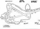
RAF Saltby
Airfield was located approximately 8 miles (13 km) northeast of
Melton Mowbray in Leicestershire about 17 mi SSE of Nottingham . Today
the remains of the airfield are located on private property being used
as agricultural fields and as a private glider airfield. [See
"RAF Bases as they appear today"]
[Read Troop Carrier Aircraft Reposition Order]
[Read Troop Carrier Mission Report]
|
9TH AIR FORCE
|
|
The 314th Troop Carrier Group at Saltby
flew 60 C-47s to drop men of the 508th Regimental Headquarters and Second
Battalion in Normandy on 6 Jun 1944. The aircraft comprised Serials
20 and 21. The Group also flew resupply and reinforcement missions
on D+1. The 314th received a Distinguished Unit Citation for these
operations.
RAF Station Folkingham
(USAAF Station 484) is near Folkingham, Lincolnshire, about 31 miles
SE of Nottingham in the Midlands area. In the early hours of 6
June, 72 C-47s of the 313th Troop Carrier Group left the station to
drop paratroops of the 508th PIR's First and Third Battalions near Picauville
France. The aircraft comprised Serials 22 and 23. The Group
also carried out a re-supply mission on D+1 and was awarded its second
Distinguished Unit Citation for its part in the invasion.
During the course of these operations, four C-47s
were lost and many were damaged by light flak and ground fire.
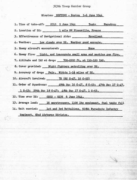
Mission Boston was a parachute combat assault
at night by the U.S. 82nd Airborne Division on June 6, 1944, part of
the American airborne landings in Normandy. Boston was a component of
Operation Neptune, the assault portion of the Allied invasion of France,
Operation Overlord. 6,420 paratroopers jumped from nearly 370 C-47 Skytrain
and C-53 Skytrooper
troop carrier aircraft into an intended objective area of roughly 10
square miles (26 km2) located on either side of the Merderet River on
the Cotentin Peninsula of France five hours ahead of the D-Day landings.
Paratrooper briefings were held at 1900 hrs, 5 June
44, aircraft departures began at 2115 hrs with 20 second spacing
and arrival over DZ-N (49o 24' 27" N- 01o 22'
36"W) on the Cotentin Peninsula was slated for 0115 hrs the next morning,
June 6, 1944. The lead aircraft was projected to return to RAF
Folkingham at 0436 hrs and the last due to arrive at 0510 hrs...
The route to DZ-N was via code-named sites, K-Atlanta,
F-Burbank, B-Cleveland, N-Dallas, D-Elko, G-Flatbush, L-Gallup, C-Hoboken,
Peoria-Center Point (DZ). The return route was via Paducah-Spokane
and returning to inbound flight path at L-Gallup,
See Map
|
|
RAF Base
(Station #)
|
Troop
Carrier Group |
TC Squadron
|
Squadron
Code
|
Serial
|
Chalk
#
|
#AC |
C-47 |
C-53 |
508th
Company
|
Take Off
|
Time on
DZ N
|
|
Saltby
(538)
|
314th TCG |
62nd Squadron |
E5 |
20 |
Chalk
1-9 |
9 |
16 |
2 |
Hq/2
|
|
0208
|
| |
|
|
|
Chalk
10-18 |
9 |
Co D
|
|
0208
|
| |
61st
Squadron |
Q9 |
20 |
Chalk
19-27 |
9 |
14 |
4 |
Co E
|
|
0208
|
| |
|
|
|
Chalk
28-36 |
9 |
Co F
|
|
0208
|
| |
32nd Squadron
|
S2 |
20
|
? |
|
|
|
|
|
|
| |
|
|
|
|
|
|
|
|
|
|
|
|
Saltby
(538)
|
314th TCG |
|
|
21 |
Chalk 1-9
|
24 |
|
|
Hq Hq
|
2338
|
0214
|
| |
|
|
|
|
|
|
|
|
|
|
|
|
Folkingham
(484) |
313th TCG |
49th
Squadron |
H2 |
22 |
Chalk
1 - 18 |
18 |
10 |
8 |
Hq/1 & Co A
|
2315
5 Jun 44
|
0222 to 0235
6 Jun 44
|
 |
Mission NEPTUNE-Boston
5-6 June 1944
Summary report |
|
|
|
Chalk ? |
13 |
|
|
Co A |
|
47th Squadron |
N3 |
22 |
Chalk
19 - 36 |
18 |
17 |
1 |
3rd Bn |
|
29th Squadron |
Z7 |
22 |
Chalk
37 - 54 |
18 |
18 |
- |
3rd Bn |
|
48th Squadron |
5X |
22 |
Chalk
55 - 72 |
18 |
17 |
1 |
3rd Bn |
| |
|
|
|
|
|
|
|
|
|
|
|
|
Folkingham
(484)
|
313th TCG
|
? |
? |
23 |
Chalk 52 |
36 |
? |
? |
Hq/3
|
|
0226
|
| |
|
|
|
|
|
|
|
|
|
|
|
|
Cottesmore |
|
508th Riggers
|
|
|
|
|
|
|
|
|
|
The two character code on the nose indicates which squadron
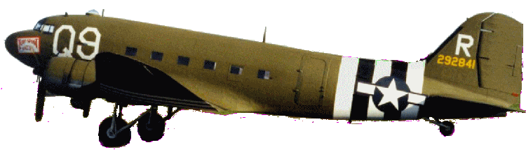 the aircraft is assigned to. in this case "Q9" indicating the 61st Squadron
of the 314th TCG. Perhaps most important is the tail number.
Each C-47 had a manufacturer's serial number unique to that aircraft
by year of manufacture. The full serial number located on a plate in
the cabin would include a prefix, for example "42-", followed by a four,
five or six digit serial number. That serial was painted on the
vertical stabilizer (tail) of the aircraft as a quick identifier.
the aircraft is assigned to. in this case "Q9" indicating the 61st Squadron
of the 314th TCG. Perhaps most important is the tail number.
Each C-47 had a manufacturer's serial number unique to that aircraft
by year of manufacture. The full serial number located on a plate in
the cabin would include a prefix, for example "42-", followed by a four,
five or six digit serial number. That serial was painted on the
vertical stabilizer (tail) of the aircraft as a quick identifier.
Since all the aircraft were manufactured in the same 40's
decade, the tail numbers began with the second digit of the entire serial
number. As such, the serial number for aircraft 42-92841 would
appear on the manufacturer's plate in the cockpit but the tail number
was truncated to "292841". The large letter above the tail
number was the radio call sign for the aircraft, i.e., "R", for "ROGER".
This aircraft was nick-named the "Turf & Sport Special" and carried
men of Company E in a stick led by Lt Eugene Hetland. |
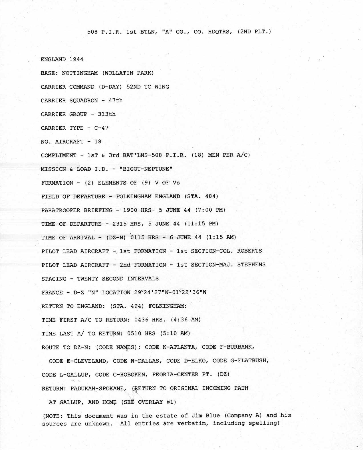
 Operation
Overlord, Mission NEPTUNE Summary Operation
Overlord, Mission NEPTUNE Summary
Various elements of the mission planning are
summarized including the TCG Wing, Group and Squadron, number and
type of aircraft as well as estimated time of first aircraft
departure, takeoff spacing, route and time of first aircraft return.
(All entries made by Jim Blue, Co A and probably were used as
briefing materials to lecture groups, school children etc. A
number of errors, both factual and spelling can be noted) . |
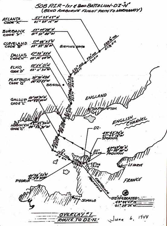
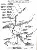 Operation
Overlord, Mission NEPTUNE, overlay route map to DZ "N: Operation
Overlord, Mission NEPTUNE, overlay route map to DZ "N:
(scale of 1:2,500,000) Note that the
major checkpoints are named after U.S. cities and each point-to-point
flight leg shows a compass heading and length in miles. These
two items enabled navigators to calculate flight durations of each leg
and predict times of arrival to ensure the course was maintained.
The letter codes for each checkpoint e.g. DALLAS CODE :N" referred
to ground transponder signals used as locator beacons. Overwater
checkpoints GALLUP. HOBOKEN, PEORIA, PADUCAH and SPOKANE transponders
were aboard submarines loitering at the surface.
|
|
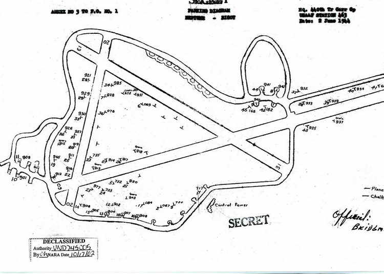
The "chalk numbers" were numerals literally written on the aircraft
with chalk so that paratroopers could easily locate the plane they were
assigned to. If a trooper was assigned to "chalk number 16" he would
be looking for that marking beside the cabin door. To find their planes,
sometimes spread over a large area on the airfield, troops, or their
drivers, were given a parking map of the airfield marked with the location
of their aircraft. The position of each aircraft is symbolized
as a "T". The chalk number and the last three digits of the C-47's
tail number appear next to the "T".
 Note that some "T" symbols are unmarked and probably denoted aircraft
other than troop transports or those not flying that day. Tail
number 937 (on far right) is designated as a "spare" in the event of
an aircraft failing to start, etc.
(This is the official parking map from USAAF archives
for the 440th at Exeter for June 5, 1944 for OPERATION NEPTUNE)
Note that some "T" symbols are unmarked and probably denoted aircraft
other than troop transports or those not flying that day. Tail
number 937 (on far right) is designated as a "spare" in the event of
an aircraft failing to start, etc.
(This is the official parking map from USAAF archives
for the 440th at Exeter for June 5, 1944 for OPERATION NEPTUNE)
When the
serials of aircraft departed they joined up in a "V of V's", i.e., 3
aircraft flew in a "V" and each group of 3 formed a larger 'V'.
Up to 45 aircraft comprised a serial with 6 elements of 9 aircraft each
in a V.
|
 |
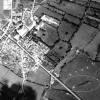 At least three aircraft were lost on D-Day by these two carrier groups.
The 313th TCG lost
aircraft
42-92868 over Sainte Mere Eglise.
This aerial view, taken on 6 June 1944.
shows the location of the crash (circled in the lower right corner)
which is approximately four-tenths of a mile SE of the town center.
At least three aircraft were lost on D-Day by these two carrier groups.
The 313th TCG lost
aircraft
42-92868 over Sainte Mere Eglise.
This aerial view, taken on 6 June 1944.
shows the location of the crash (circled in the lower right corner)
which is approximately four-tenths of a mile SE of the town center.
This aircraft was Chalk Number 16, Serial 22, piloted by 1st
Lt. William Robert Roycraft. All the crew members in the plane were
killed in the crash.
Aircraft
42-93002,was
also lost in France when its engines both stopped. The aircraft
was belly-landed about 1 mile south of "DZ "N", probably near Picauville
(MACR
6008).
In addition, aircraft
41-38698 sustained severe damage and was forced to ditch in the English
Channel (MACR 6059).
|
|
Top of Page
|
|